


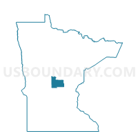
Harding Voting District, Morrison County, Minnesota
About
Outline

Summary
| Unique Area Identifier | 603208 |
| Name | Harding Voting District |
| County | Morrison County |
| State | Minnesota |
| Area (square miles) | 3.26 |
| Land Area (square miles) | 3.26 |
| Water Area (square miles) | 0.00 |
| % of Land Area | 100.00 |
| % of Water Area | 0.00 |
| Latitude of the Internal Point | 46.11936280 |
| Longtitude of the Internal Point | -94.03780260 |
Maps


Graphs
Select a template below for downloading or customizing gragh for Harding Voting District, Morrison County, Minnesota


Neighbors
Neighoring Voting District (by Name) Neighboring Voting District on the Map
- Platte Township Voting District, Morrison County, MN
- Pulaski Township Voting District, Morrison County, MN
Top 10 Neighboring County Subdivision (by Population) Neighboring County Subdivision on the Map
- Platte township, Morrison County, MN (357)
- Pulaski township, Morrison County, MN (300)
- Harding city, Morrison County, MN (125)